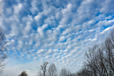
The clouds that form in the middle level of the troposphere and typically found between 6,500 and 20,000 feet (2000 and 6000 m), are known as the Mid level clouds, generally attached with the prefix alto. However, apart from Altostratus and Altocumulus, Nimbostratus clouds are also categorized as the Mid level cloud. Although these clouds are primarily composed of water droplets, depending on the altitude, vertical temperature structure of the troposphere, time of the year they can also be composed of ice crystals or a combination of the two, including freezing droplets.

Altostratus clouds are strato type of clouds that possess a flat and uniform texture in the mid levels. Characterized by a generally uniform grey to bluish-green sheet or layer, Altostratus is formed by the lifting of a large mostly stable air mass that causes invisible water vapor to condense into cloud. Altostratus clouds are sometimes called Boring Clouds for their uniformly grey, smooth and mostly featureless look.
Although sprinkles or occasional light showers may occur from a thick altostratus deck, they are not capable of yielding heavy rain. However, it is common for altostratus clouds to morph into nimbostratus clouds which are packed with moisture and can deliver a pounding. They often form ahead of a warm or occluded front and as the front passes, the altostratus layer deepens and spreads preceding the formation of nimbostratus clouds, which produce rain and snow.

Altocumulus clouds exhibit cumulo characteristics in the form of puffs, mounds, or towers. They are typically found in groups or heaps clumped together, mainly composed of chilled droplets, often accompanied by ice crystals. They are grayish-white, with one part darker than the other.
They can take on a handful of shapes and sizes. They can resemble towering castles, with flat bases and tops that often resemble cauliflower, resemble a lock of wool, can cover the entire sky on occasion and can even create horizontal tube-like structured clouds. Usually, they do not produce rain, but may indicate a weather change within a day or two. However, towering altocumulus frequently signals the development of thunderstorms later in the day, as it shows instability and convection in the middle levels of the troposphere, the area where towering cumulus clouds can turn into Cumulonimbus.

Although not prefixed with alto, Nimbostratus clouds are also formed in the middle level of the troposphere and are one among the Mid level clouds. Although found worldwide, they occur more commonly in the middle latitudes. However, it is usually a low-based cloud, but actually forms most commonly in the middle level of the troposphere and then spreads vertically into the low and high levels. Nimbostratus clouds are dark, grey, and thick enough to hide the sun completely. They produce dull and gloomy wet days.
The term Nimbo is derived from the Latin word nimbus, which denotes cloud or halo. These gloomy clouds sit low in the sky and are associated with continuous rain or snow, although not usually heavy and individual small areas may not be producing precipitation at any one moment. A Nimbostratus cloud can form from other types of clouds, like a descending altostratus. Spreading cumulonimbus clouds may also lead to the formation of nimbostratus.
