FREE ASSISTANCE FOR THE INQUISITIVE PEOPLE


Located 15 kilometres from La Fortuna, a lively rural town between the foothills of the Cordillera de Tilaran mountain range and the San Carlos plains in the central part of Costa Rica, the Arenal Volcano National Park, protecting some 16 reserves between the Tilarán and Guanacaste mountain ranges, encompasses the mighty Arenal Volcano, one of the most active volcanoes in that country and in the world, along with its neighbours, the dormant Cerro Chato Volcano, the Lake Arenal, the Fortuna River waterfall, known as Cataratas Fortuna and several natural hot water springs.

Being in the tropics, the temperature in the park oscillates between 21°C and 27.5°C, with an annual rainfall between 3,500 mm to 5,000 mm during the rainy season, which lasts from May to January, followed by the dry season from February to April.

The park area, a great wealth of geological and biological complexities, has an incredible range of biodiversity being the home to no fewer than 52 species of hummingbirds and 500 types of orchids. While its plants include various species of palms and bromeliads, guayabo de monte, heliconias, bait, ceiba, cirri, laurel, Calle los higuerones, fungi, ferns and orchids, its birds include the country's most elusive and beautiful birds, the endangered resplendent quetzal, along with parrots, orioles and brown magpies. The animal species living within the park include jaguar, deer, tapir, white-faced capuchin monkeys, howler monkeys and snakes.

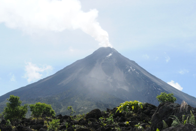
However, located on the eastern shore of Lake Arenal, the 5357 feet (1633 m) tall and conically shaped Arenal Volcano, one of the most active volcanoes in the country that has been producing lava and rapidly moving flows of hot gas and volcanic matters like rock fragments, gas, and ash away from the vent almost continuously since 1968, is the most attractive part of the Arenal Volcano National Park.

Considered as dormant, the apparently harmless sleeping giant suddenly awoke from its slumbers on 29th July 1968, when three vents opened on its west flank and began producing volcanic explosions, followed by a huge series of eruptions, which killed more than 70 people in the villages of Tabacón, San Luís and Pueblo Nuevo and another 8 people in the Tabacón river valley by a directed blast on 31 July.

Following the eruption of 1968, the volcanic activity continued with frequent smaller eruptions and lava flows, which has subsided since 2010. However, it is still extremely active and during the days, one can see smoke and cinder blocks billowing from the top of the Arenal, while at night one can watch the glowing lava pour down its steep sides. The previous eruptions created numerous Plinian columns, some of which reached 10 km (6.2 miles) in height, which attract the visitors and short trails of around 3.4 km and 2 km used lead them to pass through both secondary forest and the lava fields, up to the west ridge to the crater rim.

But in 1998, an exclusion zone of 4 km was created and access restricted to only park officials and scientists, as the tourists were frequently injured and occasionally killed by ash, falling cinders and toxic fumes. Although for the past seven years the activity at Arenal has been limited to puffs of steam and a few deep rumbles, no one can predict when the slumbering giant will rise again and the blazing cone will once again dominate the night sky. However, even when it is not erupting dramatically, the peak is still an imposing and beautiful sight.

Apart from the mighty Arenal, the Arenal Volcano National Park also contains the 3740 feet (1140 m) high Cerro Chato, an extinct volcano that last erupted a little over 5,000 years ago and has a collapsed crater, containing a picturesque lagoon. There are two trails leading to it, one of which starts near the Arenal Observatory Lodge on the southwest and the other from La Fortuna Waterfall to the northeast, which are extremely steep in sections and muddy during the rainy days. Some portions of the trails are nearly vertical on the last section down from the rim of the lagoon, where the trekkers would have to use the strong tree roots and branches to keep balance and move up. However, the government has closed the trails to Cerro Chato from the Green Lagoon Lodge and Arenal Observatory on July 2017, making it illegal to climb the Cerro Chato.

The Lake Arenal, originated from tectonic shifts that resulted in a small depression in the Arenal Valley some 2 or 3 million years ago and located at the base of the towering Arenal Volcano with its cloud-capped summit, is the country’s largest landlocked body of water, covering nearly 33 square miles (85 square km) and a depth of around 200 feet (60 m), that provides essential hydroelectric power generation for the country. Lake Arenal was tripled in size with the construction of the Arenal Dam in 1979, when the town of Arenal was relocated to higher ground and the old towns of Arenal and Tronadora were abandoned at the bottom of the lake. Apart from a boat ride, the lake is the perfect place for various water activities, among which kayaking, paddle boarding and windsurfing are the most popular. The Lake Arenal is also one of the most loved windsurfing destinations in the country.

The 246 feet (76 m) tall La Fortuna Waterfall, known as Cataratas Fortuna and located in the Arenal Volcano National Park, is fed by the Fortuna River that plunges over the cliff and descends into two pools. Guests are encouraged to swim in the stream and small rapids below the falls for which they are to hike down around 500 steps along a staircase carved into the hillside.

Apart from the above, there are several man made hot pools, fed by thermally heated underground streams, along the road linking Arenal and La Fortuna, a small town that serves as the gateway to the Arenal Volcano National Park, offering natural mineral pools at varying temperatures, swim up bars and a hot waterfall set in tropical gardens, along with massages, hot rocks, water-jets, vegetable and salt rubs and volcanic mud packs.